
2020.
Will Koeppen created a lovely, and more photogenic, report from this trip. Check it out here.
I have a top-secret goal of piecing together trips to connect Kaktovik to Juneau, motivated by the theme song to Molly from Denali. I have traveled most of the distance between those communities, but the remaining segments require passing through villages. With COVID in Anchorage, and thankfully not yet a problem in the villages, 2020 was not the right year for village travel. So I sat down with some maps to figure out what I could do from the road system.
My friends Andy Dennis and Kai McGrath mentioned that they were going into the Arctic Refuge and had a resupply flight. One of my road system ideas was to visit the Sadlerochit Mountains deep in the Arctic Refuge, so first I tried to convince them to change their plans, and then I asked if we could include some food on their flight.
We pulled in Will Koeppen, my friend and co-worker, who helped us with logistics on our previous trip through the Refuge. Will was excited for the opportunity to return to the Arctic Refuge, and had been logging a ton of hiking miles in May, which made Sarah and I nervous about him being bored with a hopefully somewhat casual pace. But even with Will committed, we nearly backed out at the last minute.
When Sarah started Mind and Mountain, her online physical/mental health business, she wanted it to appeal to people of all shapes, sizes, and colors. But her marketing, mostly word-of-mouth and social media, pulls in people like us—middle class, primarily white, outdoorsy people. Sarah started a multi-year effort to learn how to create a genuinely welcoming environment, and how to actively be an “anti-racist,” rather than just “one of the good” white business owners. All of this is a preface to say—the deaths of George Floyd and Breonna Taylor and the civil unrest related to the Black Lives Matter movement in June strongly affected Sarah. COVID was terrible enough, but it then felt especially insensitive to go on a wilderness trip when people across the US were rallying for basic fair treatment.
Ultimately, the green-light came from feedback from one of her mentors that the anti-racism battle had been going on for hundreds of years, and that there would still be a role for Sarah after the trip, and she would probably come back rejuvenated for the work that needs to be done. So we go.
With Andy and Kai’s help, this was another wilderness trip done cheaply with “logistics by convenience.” A week before our departure, Andy and his crew drove two cars to the Brooks Range. In addition to putting food on their flight, we were able to use their cars to shuttle our car to Prudhoe Bay, where we would finish our trip.
We stopped at the Arctic Getaway B&B in Wiseman on the drive north; it is always such a treat to catch up with Uta and Berni Hicker. We traded our extra road trip food for a loaf of fresh bread, gummy bears, and radishes straight from their raised beds. Yes, an unfair trade.
The Plan
The majority of the hiking we do in Alaska is off-trail, and usually involves swamp, brush, tussocks, snow, loose rock, etc. Easy walking is the prize we are continually seeking, and the Brooks Range features some of the best in Alaska. I once overheard someone describe a valley in the Arctic Refuge as a “mall-walk.” And of course, hiking is more pleasant with light packs. Our effort to find good walking with light packs resulted in a trip plan consisting of three ~weeklong segments:
- Hike and packraft from the road to the Sadlerochit Mountains
- A “backpacker’s loop” in the Sadlerochits without carrying boats (10-pound savings)
- Exit to the North Slope and back to the haul road at Prudhoe Bay
The Sadlerochits were an objective because they have a cool name, are a geographic anomaly, and have a reputation for pleasant hiking. The name derives from the local (Inupiaq) “Shudtaroshik,” meaning, “the area outside of the mountains,” which describes its unexpected position 15 miles north of the front of the mountains to the east and west. Dictionary of Alaska Place Names.
I was especially obsessed with the Sadlerochits for the opportunity to visit “the best ridge walking in the Brooks Range,” which was my conclusion based on studying satellite imagery. I even tried to figure out how to get bikes flown so that we could bike the ridge.

The Sadlerochit formation also hosts the petroleum reservoirs actively extracted in Prudhoe Bay and proposed for development in the 1002 area of the Arctic Refuge. I think it is accurate to say that the Sadlerochit formation is the single feature most responsible for Alaska’s evolution since statehood, both good and bad.
I’ve never been a fan of the oil industry, but I do love rocks. When I arrived at UCSB for geology grad school in 2000, my advisor enrolled me in a class called “petrotectonics.” I was pissed. I stormed into his office and told him outright that I had no interest in learning or aiding the petroleum extraction industry. Brad was impressively patient with me as he explained that “petra” means “rock” and “tectonic” means “building or construction.” The course was about how rocks deform, not about petroleum. I was embarrassed. It didn’t stop me from wearing a sign that said “I survived the Exxon Valdez Oil Spill” when Exxon representatives came through the department for recruitment.
To the Sadlerochits
We started hiking late in the evening after driving the shuttle to Prudhoe Bay, mostly because our legs were restless after two days in the car. Thunderhead clouds were looming, and we knew it wouldn’t be long before they broke open. We worked our way toward the Sag, keeping each new candidate tent site in mind so that we could race to set up the tents when the rain came. The strategy worked, and we were warm and dry in our tents when it started to pour. This was the second year that Sarah and I used the HMG Dirigo tent, and although it isn’t as waterproof as we’d like, we love that it can be set it up in less than two minutes.
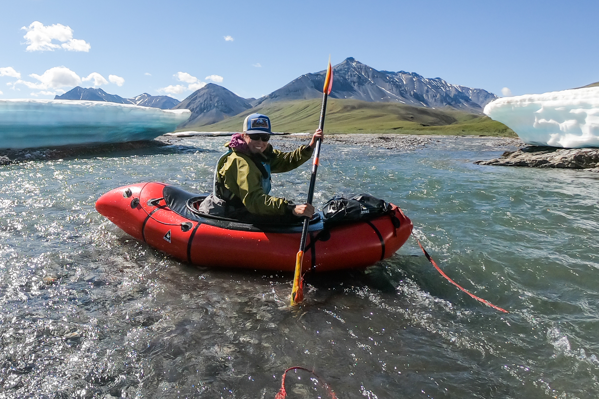
Andy’s flight was going to the Ivishak River’s headwaters, so we needed to go there too. The route to the Ivishak was mostly familiar to us from our 2017 hike, and we were able to see a few new places and re-visit others that we had appreciated. We carried six days of food and only one packraft; our light packs allowed our bodies a gentle transition into mountain mode. We doubled up in the single packraft to cross the Sag river, which turned out to be a good strategy. (I had proposed a rope and floating cargo bag system, but got vetoed. Good thing—the Sag crossing was way too wide for a throw rope.)

Our route brought us past six caribou, non-biting fish at Elusive Lake, and the remnants of a missile launched as part of UAF’s Poker Flat Research Range program. We intentionally repeated our 2017 route into “Hidden Valley,” a stunning tributary in the headwaters of the Ivishak, and a sculpted 2.5-mile sheep trail. After another few miles, we reached our food cache.


On Andy’s suggestion, I had built plywood boxes for our food to keep animals out while sitting on the Ivishak. It turns out that human animals were of more significant concern.
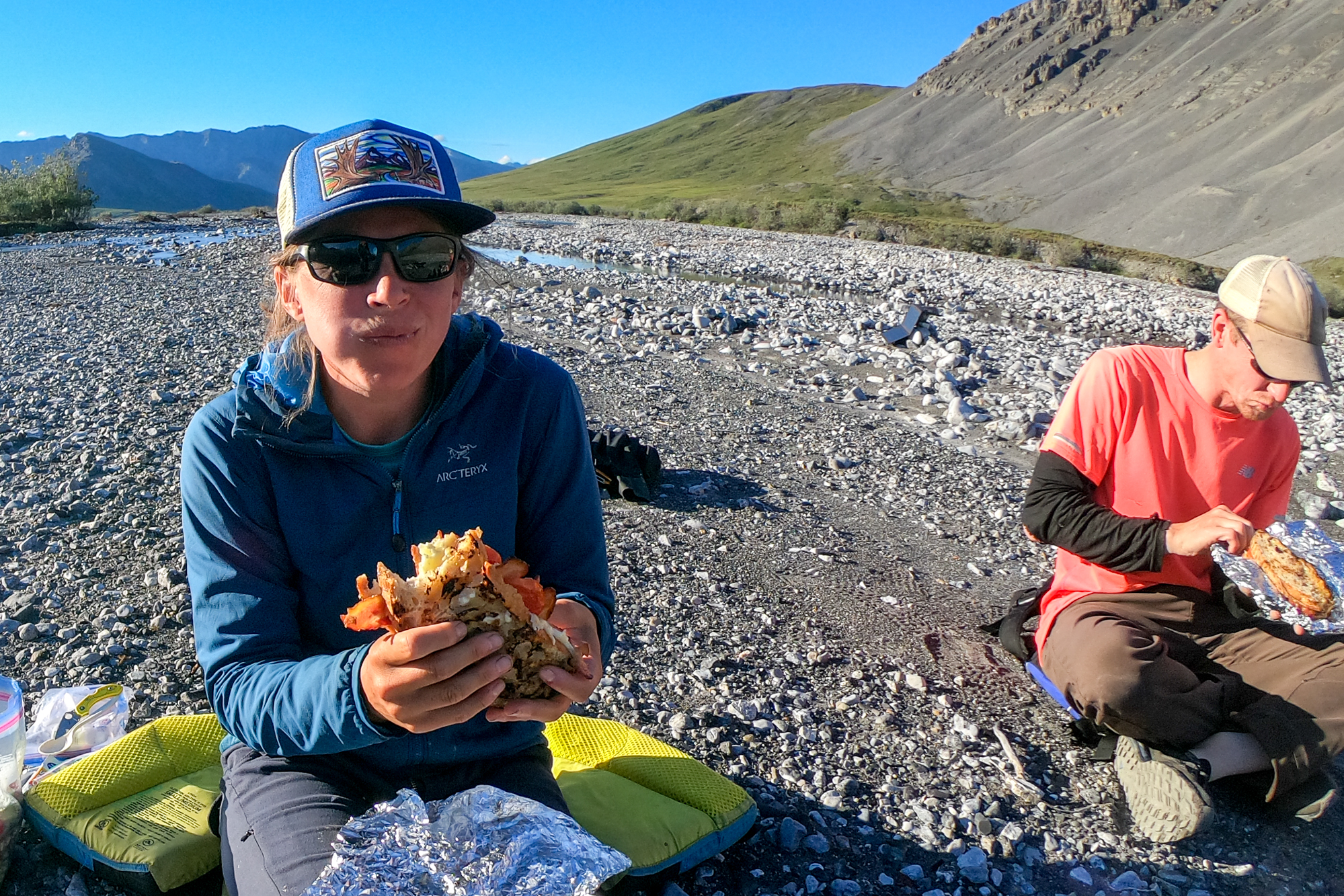
Whenever we have a food drop, I like to include a “heavy dinner” for the night that we reach the cache. Will proposed BLTs. He packed a loaf of Fire Island sourdough bread, 1.5 lbs of precooked bacon, manchego cheese, cherry tomatoes, and small packets of mayonnaise and mustard. The TMJ-inspiring sandwiches were wrapped in foil and cooked in the coals leftover from the burnt plywood boxes. Sarah packed a “summer salad” of cucumber, tomatoes, and mozzarella cheese. Shannon Kuhn, Will’s girlfriend, contributed blondies for desert Yum!
In the morning, I picked the food box screws from the ashes, and we started “walking the dog” down the Ivishak, using a leash to pull the packrafts through shallow water. After a few miles, we floated the rest of the way to the valley of Porcupine Lake. We had reached the anticipated crux of the trip.

I felt pretty smart about our trip plan—three weeks and 350 miles in the Arctic Refuge, but with light packs! Due to Andy’s flight and the “backpacker’s loop,” we could start each of our three segments with ~six days of food. With this one exception. We had to haul our most massive load, 16-days of food, from the Ivishak to the Canning River, a distance of 20 miles. I think I am generally associated with the “fast-and-light” travel, so it always makes me smile to think of how often I carry an 80 lb pack.
We had two options for the twenty-mile portage to the Canning. The northern option (blue in the figure below) promised better footing and scenery. Still, the imagery suggested intermittent canyons through the limestone, with steep scree flanks if/when we needed to get out of the stream bed. Doable, yes, but not fun with an 80-lb pack. The southern option (orange) had significantly less vertical relief but threatened a 10-mile section of tussocks and less impressive scenery. After a lot of discussions, we decided to stick with “the devil you know,” and planned to move slowly through the tussocks on the southern route. It worked, but part of me wishes we’d seen the mountain route.


We camped where the two route options joined. The last mile of hiking was along a significant wolf trail, as indicated by its narrowness (narrower than a caribou trail) and a plethora of wolf scat. The constriction was hard on my knees (one foot in, one foot out?), though I was proud that my body was still capable of moving 16 days of food 12 miles over rough terrain.
During the night the rain turned to snow. Snow during the week of summer solstice felt a bit ridiculous, so we stayed in bed until the sky broke in the early afternoon. It was a brief respite, and we paddled cold to, and then down, the Canning River. We used gallon ziplock bags as paddle pogies, which makes a significant difference for warmth and comfort.

The Canning was very scenic; no wonder it is a destination float trip. Even at flood stage, we managed to ground out in a few braids and were grateful not to be in bigger boats, but boy, put that trip on your list. We spent a night on a gravel bar covered with muskox tracks, and saw one before camping and then ~20 the next morning, including some frolicking kids. Sarah collected a bag of qiviut from the willows.

The Backpacker’s Loop

We pulled off the Canning River at Ignek Creek, the last mountain drainage before entering the Coastal Plain. Ignek means “fire,” and describes a rust-red stain seen in the creek (and throughout much of the Brooks Range), due to acid-induced leaching of metals from the carbonate rocks. We filtered the most transparent water we could find, and Sarah found a sunny lupine-filled bench to host our gear explosion as we decided what to cache and what to carry. We left six days of food in Ursacks tied up in the willows and our boats and the other gear we wouldn’t need until we started heading to the North Slope.
We walked up Ignek Creek and saw a brown animal ahead of us. We hoped it was another muskox, but then it stood up. The wind was at our back, so the bear got our scent, but it didn’t run away, it just kept to its business. Unfortunately, its business seemed to be taking it directly toward the cache we had just left in the willows. We spent the rest of the week wondering if the bear ate our food and packrafts.
We climbed out of the red creek, and Will found a high camp with a view of the Shublik Mountains across Ignek Valley. The Shublik’s have striking geology of dark (black) greenstone (ancient metamorphosed basalt) cutting through light gray limestone. The effect made it look like the mountains were always in the shade of a partly cloudy sky.
We approached “the bikeable ridge” through a fossiliferous limestone, the Wahoo! formation (my exclamation point). After carrying 80 lbs for two days, we didn’t even bother to take off our (much lighter) packs as we hunched over and picked out crinoids and other fossils.
You have probably already guessed that the bikeable ridge was not bikeable, and we knew that within miles of reaching it. As we approached the ridge, it occurred to me that the rock wouldn’t be both a cliff-forming unit (rigid) and easily weather into pea-sized rocks for good walking (friable). But I’ve got to say, I’ve never seen talus that large on top of a ridge. Sure, on the slope, no problem, but usually, the ridge itself is different, either finer-grained or bedrock. We moved slowly across ~ten miles of the ridge, but the time went by quickly with the beautiful weather, views of the Shubliks, and a few glimpses of sea ice and the Arctic Ocean 35 miles to the north.

We expected the Sadlerochits would be a hiker’s playground with easy access and tons of options. We were surprised to discover that most of the dolomite rock (closely related to limestone) formed cliff bands that made the passes steep and challenging. Sarah was like, “Wait, hold on. We raced through areas with excellent walking [the Ivishak] to get here, and there isn’t any good walking?” We spent some time studying the maps, trying to find passes that would let us traverse the mountains without being exposed to rockfall. The decision ultimately boiled down to: should we spend mellow days without venturing too far, or commit to a long loop that may or may not bring us into better hiking terrain. Will was consistently in favor of the loop, Sarah and I kept flip-flopping about our preferences. We slept on it, and in the morning, Sarah said she was leaning toward the long loop.
We walked Katakturuk Creek, a fascinating drainage because it, alone, cleanly slices through the Sadlerochit Mountains. Will said that the creek must pre-date the mountains’ uplift, to explain how it could erode through the otherwise impenetrable range. When we reached the edge of the mountains, we turned east toward the pass that Sarah had identified as the most reliable way (no cliffs) back through the mountains. The terrain got friendlier as we headed east, culminating in caribou highways up and over the pass. It turned into a 19-mile day as we continued down the pass looking for a campsite that would get sun in the morning. Our week of 24-hour sunlight spoiled us!


My favorite animal encounter was on our eastern end of the Sadlerochits. We saw more animals on this trip than others; I guess that the mixed weather gets the credit. We were side-hilling in the alpine and approaching a brown object. I yelled, “Hey!” We watched as a reclining bear lifted its head, looked left and right, and then laid its head back on the ground. The bear was supine, sunbathing, arms and legs extended long and straight. The response was so relatable, like hitting the snooze button on the alarm. “Must have been the wind. I’ll just lie here for a few more minutes.” We changed our approach so that the wind would bring our scent to the bear, and once we were in that position, we yelled again. This time the bear stood up, saw us, smelled us, and then ran away, covering miles in minutes.
We continued south to the Shublik Mountains and then west to finish our loop. The Shubliks are similar to the Sadlerochits in that they form a narrow east-west range that sticks out to the north relative to the general limit of the Brooks Range.
It was soon evident, walking up Fire Creek into the Shubliks, that we had found the good walking. Caribou trails brought us through anything that looked wet or tricky, and Fire Creek’s red canyon walls, slides, and pools of clear water were a constant source of wonder. As you probably guessed from the name, the walls and rocks were stained red like Ignek Creek.


Our final pass in the Shubliks involved walking through snow in the fog and rain, but then we were thrilled to find excellent walking along Nanook (“polar bear”) Creek, featuring more canyons, waterfalls, and cool geology. Hiking along the Fire and Nanook Creeks was the highlight of the trip.


Nanook Creek exits through a tight gap in the Shublik mountains, quickly transitioning to a broad plain formed by thousands of years of braided stream deposition. The walking was excellent. We noticed a stone circle. On these trips, I’m always scanning for signs of Alaska’s native heritage, looking for smoke stains on cave walls, etc. This stone circle was the coolest thing I’ve found. Vegetation nearly covered the rocks, we walked past them, and then something about it caught my attention. The location made sense; it was a perfect perch to watch for animals passing in and out of the Shubliks along Nanook Creek. I assume the circle of stones held down caribou hides around central poles, and I see references to both dome-shaped (itchalik) or conical (tupiq) shelters online. There wasn’t a wood source anywhere nearby, so they must have carried those poles a great distance. There is wood on the North Slope, presumably drifted in from the MacKenzie Delta in Canada. It was amazing to get a glimpse into traditional living on this land.


Exit to Prudhoe Bay
The day after being awed by the stone circle, we experienced a cultural shift and followed seismic-line scars through tussocks. This day was the anticipated second crux of the trip, a 10-mile tussock portage from the Canning to the Kavik River. We portaged to the Kavik because the Canning trends NNE, and the Kavik flows NNW. A 10-mile portage would save us 40 miles of travel on the coast. Math.
The first seismic scar was that we crossed was the most prominent. The perfectly straight line was from bladed tractor travel in the 1960s, which left a significant depression that had subsequently filled with ponds due to melting permafrost. We were all surprised by how poorly the vegetation had recovered over 60 years.

On the way to Kavik River, we crossed several more subtle vehicle tracks from the mid-1980s. We walked along one section several hundred yards before Sarah realized we were following a 40-year old vehicle track. I was leading and chose a direction that had slightly lower relief between the tussock mounds. I probably wouldn’t have noticed the subtle difference in footing if I weren’t so well tuned-in to the environment after two weeks of wilderness travel. Looking back, we could see the track extend for miles, a faint line demarcated by the cotton grass in the track being less in bloom than the grass outside the track. More information on these tracks is available via Matt Nolan’s blog, FWS, UAF, Ecological Applications Journal, and these NYT articles (tracks, platforms).


When we reached the Kavik, I was disappointed to find barely enough water to float. Looking more closely at the map, I realized there would be no significant tributaries (to add water) for the next 50 miles. On top of that, a hard northwind blew from about 9 AM to 9 PM each day (the air over the land warms up faster than the air over the ocean… the warm air rises, creating low pressure that is filled by cold air flowing heading south from the ocean). We decided to flip days and nights to avoid the onshore headwind and spent the next three nights paddling 60 miles. We had to actively paddle much of the time, eight hours a day. I didn’t love this section and didn’t take any pictures.
The highlights of the Kavik/Shaviovik float were a massive permafrost cutbank, at least 15 feet tall with an overhanging chunk that collapsed into the river soon after we passed, and then a herd of ~4000 caribou that we saw just a few miles from the coast. There were a handful of young caribou jumping around and acting wild, so much fun to watch. We watched the caribou as long as we could before getting cold in the not-yet-warm 4 AM sunlight.
We saw a single caribou where the Shaviovik (the Kavik flows into the Shaviovik twelve miles from the coast) opens into the ocean, acting strangely. At first, we thought it was just curious, but then we noticed that it kept returning to an object on the beach. We paddled near enough to identify the object as a dead calf. Our best guess is that the calf drowned during a river crossing.
We set up camp on the coast in a thick sea fog that never entirely dissipated. I was nervous that the walking would be swampy, but it was excellent. I mean, there were swamps, but nothing terrible. We were able to walk the beach (mostly silt) or tundra (firm ground with melting permafrost depressions). We walked a short section of barrier islands and then packrafted through sea ice to get back to the coast. We weaved between automobile-sized plates in our packrafts. Not efficient but very enjoyable.


We saw more signs of the petroleum industry as we approached Prudhoe Bay. At first, we thought we were very near some infrastructure and might get in trouble, but then we realized we weren’t near, it just looked that way because everything was big—big boxes, big trucks on big wheels, etc. We floated over and walked under a pipeline working our way west.

We reached Deadhorse around midnight on day 21. Since we were on a flipped day/night schedule, we drove south a few hours to escape the cold sea fog (night temperatures had been in the low 30s). We didn’t avoid the fog, but our sense of accomplishment kept us motivated to keep trying. We ended up camped off the road between sloppy fire rings, toilet paper, and piles of campers’ trash. The fog burnt off in the early morning, and I caught two grayling on two casts for brunch.
We stopped again at the Hickers, this time for ice cream, and arrived in Fairbanks after midnight intending to drive through town and sleep in the open air one last night. We gorged on Papa John’s pizza and were joined by Andrew Cyr, a friend from the Classics who didn’t think it was unusual to receive a text at midnight inviting him to parking-lot pizza. Andrew convinced us to spend the night with him in town, which was fortunate because we woke up to find a flat tire, which he repaired.
We started plugging into the news and were impressed that things were about the same, equally disturbing, as when we had left. It had been such a treat not to think about masks and politics.
When we decided not to cancel the trip during the Black Lives Matter protests, Sarah proposed that we do some social justice homework while in the mountains. She loaded Me and White Supremacy by Layla Saad on her Kindle, and we worked through a chapter a day for most of our trip. I was concerned that the homework would be a distraction from the wilderness, but it wasn’t. The book focuses on the Black population, but we also answered the prompts regarding native Alaskans, since we have more experience interacting with the native community. That fit well with our daily experience of following caribou trails, looking for fish, and pondering how the native Alaskans have and are stewarding this land.

I was very impressed with Saad’s book. Each chapter was bite-sized, short enough that one of us could read it out loud, and then we would spend half an hour answering the prompts as we waited for dinner to rehydrate or took a break at a mosquito-free spot. These conversations helped me identify the inherited racism in our society, and take responsibility for the work I can do to kick racism out of myself and the system.
I’m looking forward to science getting us through COVID and doing the work to become an anti-racist. And I’m incredibly grateful to have access to the wilderness to ground myself in the fresh air and animal tracks. We developed a mantra to trust the caribou trails while navigating the Sadlerochits and Shubliks: “Do the bou!” I wish we could follow them through human rights and conservation. I think the next best thing is to follow the people who are doing this work the best, people like Saad, Jodi Potts and the rest of the Native Movement team, Sam Alexander, and other stewards of this land and its peoples.
Thanks for reading and being a part of this journey!

Good morning from New Jersey – Thank you for taking the time and effort to share and document your trip. We speak with great fondness here of your efforts there and it serves as both education and inspiration. All the best, BG
Thank you!
Fantastic!
Thanks for sharing. It has been a gift to endure this time without being able to travel. So thank you
Thanks for the trip report Luc! I read Will’s report and your write-up and his posting in Instagram complimented each other beautifully. Sounds and looks like you three had an awesome trip.
We did! It was a great trip.
Luc, This is an ingenious way of getting to the Sadlerochit’s without the cost of a flight and from the sounds of it it’s totally worth the effort. It’s a bummer you took the Porcupine Lake option to the Marsh Fork when there is a much more enjoyable option. https://caltopo.com/m/1C87 I’ve done both and would take the southern way again, it’s maybe my favorite place I’ve been in the Brooks. I’d say its right up there with the area between the Ribdon and Ivishak or upper Accomplishment creek for me. Anyways I always appreciate your trip reports and will certainly use some ideas I’ve gotten from you next time I make it to the Brooks
Thank you Dusty! We took your route a different year, and yes, it is an awesome area, much more scenic than Porcupine. Our route across that section this year was as short as possible since we were carrying our maximum loads, 16 days of food and fuel.
I would really like to see the options further north from Porcupine. But, probably not going to hike in their again without a flight!
Yeah, no matter how you look at it it’s a long walk to get to the Marsh Fork. I feel fortunate to have made it out there a few times for work so I didn’t have to pay for such an expensive flight, but there’s enough to explore that ultimately it’s worth making the trip.
Would you jump the 10 miles over to the Kavik River again, or would you deal with the longer traverse along the cost and run out the Canning?
I think we were lucky to float as much of the Kavik as we did.
I would either expect to walk the Kavik (it looked like pretty good walking), or take the longer route to the coast and walk the coast. I really enjoyed the time we spent on the coast, but it was cold and gloomy with ice fog.
Thanks, I’ve had beautiful days and ice fog days on the coast, but both are better than an expensive flight 😉
I just found you in the last couple days, i consider myself a mountain person but am blown away and super inspired by your adventures, routes and photos. Thank you so much for sharing!
Cool! But probably misleading to catch me after 20 years in ‘the game’ … I’ve had a lot of trips and plans that didn’t work out too!
Hi Luc. I just stumbled on your trip log here while I was doing some GIS work and noticed that you reference having passed some rocket debris early in your trip. I manage the Recovery Program at Poker Flat and was hoping you might be able to give me an idea of where you found the debris. We try to maintain a clean range, so when the public finds debris, we recover it, and pay the finder a reward. We had a report along your route in 2018 at 68.6586, -147.1763 in a valley near the headwaters of the Ivishak. If the debris you found was elsewhere, would you be willing to work with me to locate it on a map? If your sighting was near that location, will you please confirm? Thanks!
What an amazing trip! I’m having trouble exporting the kmz file into Gaia from the google map source? Would you mind sharing your route as a kmz file link?
I don’t have an easy way to embed files. Did you try this:
1. Click on the ‘view larger map’ icon in the upper right. This will open the map in its own window.
2. Click on the three vertical dots icon (upper right) –> download kml
And keep in mind that my routes are drawings … not recordings!