

Google Earth
Google Earth is the most mature interface for viewing historic (“best”) satellite imagery, but there are a few other sources to consider.
Check out my detailed page on how to use Google Earth for route planning.
ESRI Worldview
In Alaska, when Google Earth’s resolution is poor, ESRI Worldview is often better. You can view ESRI Worldview as a layer several ways:
- Bing’s aerial imagery service
- Direct from ESRI, with timestamps
- GaiaGPS.com with the Premium subscription

ESRI Worldview via Bing 
Google Earth via Gaia
Arctic DEM
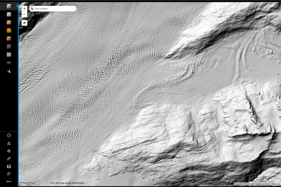
ESRI also serves 2-m resolution ArcticDEM (Digital Elevation Model) imagery from the ongoing effort to remap the arctic (Polar Geospatial Center). There is no easy way to get this imagery to Google Earth or other mapping platform, but the resolution is mind-blowing and useful for things like evaluating crevasse hazards.
The site is often bogged down, which prevents me from using it frequently. It is getting better.
Advanced access can follow this advice from Sal Candela, Ohio State University:
- Download the shape file with all of the strip/mosaic data (http://pgc.umn.edu/system/files/ArcticDEM_Tile_Index_Rel3.zip http://pgc.umn.edu/system/files/ArcticDEM_Strip_Index_1.zip ).
- Use Arc or Qgis (free) to find the filenames that fall under the area you are interested in.
- Use either FTP (ftp://ftp.data.pgc.umn.edu/elev/dem/setsm/ArcticDEM/ ) or web access (http://data.pgc.umn.edu/elev/dem/setsm/ArcticDEM/) to grab the files directly (without using the ESRI interface).
Hi Luc, Thanks for both of your posts this morning. I am teaching a gaia gps/ cal topo/ google earth class for our SAR team, Juneau Mountain Rescue. We have the team subscription and use gaia gps in the field. Mostly in operations we make scale maps in caltopo and load up all the search tracks from teams in the field. It is a great write up and I will share your link with our team. The satellite imagery links are very useful as well. I use MODIS and satellite imagery to track international pollution for Regional Haze at work and satellite imagery for SAR and trip planning.
As always, I appreciate your expertise in trip planning! My Fairweather skis are awesome and it was great to build them with Graham. I hope your upcoming trip plans are coming together. I think I might head back to the Brooks Range this summer with Ed, but I have some climbing objectives in the works for August, so I am not sure if I will have enough vacation.
Take care, Dea Huff
On Mon, Mar 11, 2019 at 11:46 AM Things To Luc At wrote:
> lucmehl posted: ” Google Earth is the most mature interface for viewing > historic (“best”) satellite imagery, but there are a few other sources to > consider. ESRI Worldview In Alaska, when Google Earth’s resolution is poor, > ESRI Worldview is often better. You can view” >
Hi Dea! I accidentally broke my site over the weekend, so am working to update this content as it gets moved into a new theme.
I wish I could be a part of your training! I’m heading to Takleetna Friday to go over Gaia with the Denali Rangers. I’ll update the Gaia content soon!